Longitude in Maritime History
Latitude and longitude concepts and ideas about determining these important points in the world BC III. It dates back to the century. We would like to talk about how longitude process and order has developed in maritime history. II. YY. The coordinates of the places lined up in the world's first atlas, prepared by Protemaios in the middle, are given as longitude and latitude. According to Atlas, the beginning of latitudes is the Equatorial belt and the border of the world. The initial longitude passes through the canary Islands. At that time, the longitude problem started and moved to many different points before being placed in London, where it is today. These moving points are important points of the world such as Azores, Rome, Capo Verde, Paris, Jerusalem, Copenhagen, Pisa, St Petersburg, and Philadelphia.
Nowadays, every sailor who has a basic level of navigation knowledge can easily find out what degree of latitude he is by looking at the heights of the sun, the length of the day and the guide stars. By looking at the time difference between the degree of latitude he finds and the starting meridian, he can estimate the longitude he is in. Of course, with today's technology, you can determine the location with modern devices without the need for such calculations. XIX. Unfortunately, latitude and longitude measurement was not so easy until the beginning of the century. The latitude could only be calculated with a maximum margin of 10 nautical miles with the help of a crossbar, astrolabe or reverse site at sea. During the middle ages, the distance between the ports could only be determined roughly with the help of hourglass and longline. With the help of the wind and the stream, the information obtained was transferred to maps called portolan. The sailors would follow the lines from the wind rose on these maps and maps, where they were placed at important bearing points and where they could determine the next destination. Unfortunately, these maps were not sufficient to use in the open seas. For this reason, sailors usually traveled on long and long sea voyages by following latitude parallels. Not knowing the degree of longitude meant not knowing when to reach the land for the sailors. This brought many problems. Even the most famous discoveries and captains were having trouble determining the degree of longitude and lost their way under the conditions of the period.
In 1492, Christopher watched 27 North parallels during the Columbus expedition and descended on the island of Santa Domingo in the Bahamas, assuming he set foot on an Indian Island. Knowing that the world is round, Kolomb thought that he could reach India by going west through the line. Because, according to his calculations, India was on the same parallel. Unfortunately, Columbus, who miscalculated the world and acted in this direction, did not know that he set foot on a new continent. Many more explorers didn't know that the place they stepped on was a new continent. This continued until the longitude problem was resolved. Even thousands of sailors died in the seas until the longitude problem was solved. Not knowing the degree of longitude caused the sea voyages to take longer than expected and naturally not enough supplies left on the ship. Seafarers, who could not be fed enough, were caught with various diseases and died in time.
XVII. The astronomical discoveries made in the 17th century brought important developments for the longitude problem. The fact that the longitude problem can be solved by observing the movements of the planets and stars has been reached. Having discovered Jupiter's moons, Galileo discovered that longitudinal determination could be made by looking at the time they were held. Galileo also put forward the idea that pendulums could be added to the clocks during that period. After Galileo's discovery, Giovanni Domanica Cassini has prepared rulers that calculate when these eclipses will take place. Thus, Galileo's discovery became feasible. The development of pendulum clocks in the same period allowed time to be measured more precisely. These two important developments played a very important role in the development of cartography and even enabled the start of a new era. After this development, observatories were established and precise longitudinal measurements were made and new maps were prepared.
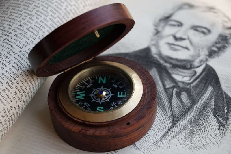
Longitude problem on land has been solved with the use of astronomical observations and pendulum clocks. Unfortunately, these developments were not enough to solve the longitude problem at sea. It was never possible to observe Jupiter's moons while cruising at sea. During pendulum hours, he was negatively affected by the wobbling of ships at sea and did not show accurate results. Besides, the temperature changes experienced when going to different ports caused the hours to go forward or lag. During the process, many interesting and different methods have been tried to measure the degree of longitude at sea. One of these methods was the anchoring of station ships at some points of strategic importance in the ocean. Will the anchoring ship fire fireworks from the ship at certain time intervals? It would allow the counting of the seconds and the distance to be determined according to the speed of sound for the ships passing by. The most plausible idea among the ideas put forward at that time was to know the distance between the north and the magnetic North and find the degree of longitude. For this purpose, a compass was developed at that time. Afterward, it was determined that this compass was affected by terrestrial shots in different places and the compass needle does not always show the exact North region.
In 1707, as a result of miscalculations of four British warships, two thousand sailors died when Scilly hit the rocks off the coast. This great disaster in English maritime history leads to the formation of public opinion to resolve the longitude problem. London seafarers and merchants want to work on the problem of longitude in their petitions to the government in 1714. The British government then passes a law they call longitude law, and they explain that they will create a high jury, among them Isaac Isaac and Edmond Halley, and will award prize money to the person who developed the method to find a solution to the longitude problem. It has been announced that different rewards will be given to individuals according to different error margins. It was of great importance to be able to measure with 1 degree of error in the conditions of that period. In the announcement, there have been extremely important developments in maritime history and many methods have been developed. With this method, the British Navy, which has made significant progress in the longitude problem, gains a great advantage in the seas. The British Government, which seized the overseas places in this way, has been one of the most important naval forces until the defeat it will face in the Dardanelles in 1915.
Significant representatives, who came together at the International Meridian Conference in Washington in 1884, accepted the Greenwich meridian as a starting point and after that date, Greenwich meridian was taken into consideration in all calculations. The red globe, still on top of the Greenwich observatory, would guide the captains on the Thames. The captains used this red sphere to set the stopwatch they had at 13.00. Today, the red sphere is still set at 13:00. This means that the longitude problem has been resolved in this region. So it has become a completely traditional representative ritual.
Longitude is very important in maritime history. Because of this problem that could not be solved for many years, many seafarers lost their lives. Also, this situation led to late discoveries. In other words, perhaps it is among the reasons for the beginning of the failure of many events in the world.