MYSTERY ON THE MAP OF PIRI REIS
The map drawn by Piri Reis five centuries ago included the shores of South America, the western coasts of Europe and the coasts of America. The map was discovered in 1929, but until the discovery of the map, nobody even knew that such a map existed. During the 85 years since the map was examined and many studies were published about the map. What should be the reason why the map was so special? What made this map so mysterious?
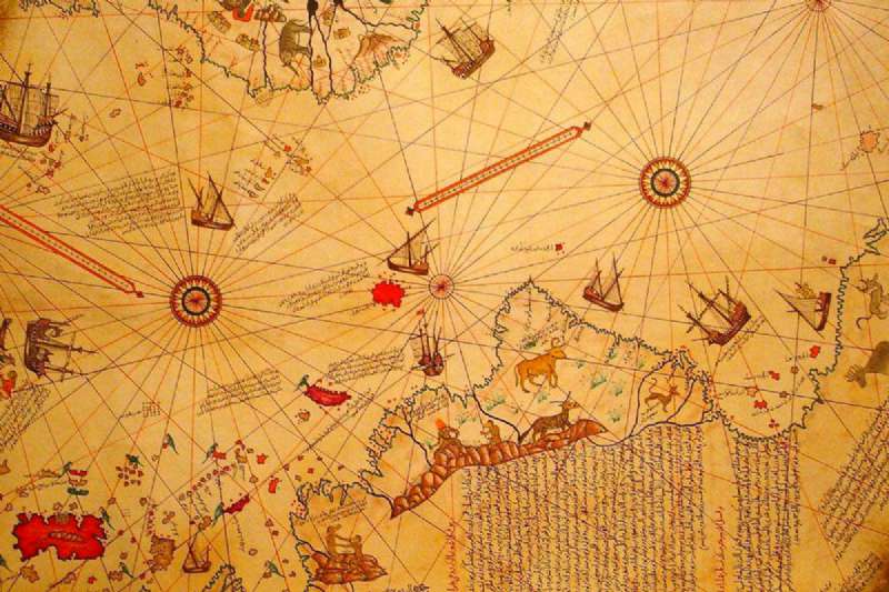
In addition to hosting the newly found American continent at the time, this map also contained many secrets and important maritime information. As a result of this information, many theories about the map have been put forward. In this study, the information will be given about the map of Piri Reis and explanations will be made about the mystery of the map. Detailed information will be given to understand Piri Reis. At a time when longitude calculations could not be made, the world map was drawn by Piri Reis. The exact drawing of the land would be real as a result of the discoveries in the 17th century. The maps available in the same period provided information based on symbolic expressions. The narratives were considered very important for these maps. The ships would sail according to the guidelines and would determine their direction according to the bearing points on the map. These maps were prepared using the Portolan technique. The Italian word "portolano" was used to mean being connected to ports. In the maps prepared with this method, it was possible to determine the distance between the coasts, islands and harbors and the lines between them by passing through certain reference points. The distance between these lines was very important in this regard.
In the maps prepared according to the Portolan technique, wind roses placed at some important points were used. The lines emerging from the windrose linearly intersected each other. The 32- or 16-arm windrose points showed the directions on the compasses of sailors. Similarly, these maps included secondary compass roses. These maps also had scale scales. The map was drawn by Piri Reis also includes rhododendron, secondary compass roses, and scale scales. Unfortunately, this map has not been completely available to us. Naturally, it is not possible to estimate how much wind hole and secondary compass roses and scale scales are. The note on the side of the map of Piri Reis states that he used 20 different maps that were available when he was drawing this map. He mentions that one of these maps is the map of Columbus. In his book called Bahriye, he stated that he participated in three different trips with his uncle Kemal Reis and Columbus. He explained that during these expeditions, they captured a Spanish sailor and captured the map of Columbus in this way. Presumably, Piri Reis may have benefited from the map of Columbus during the drawing of the Caribbean. The incorrect location of the map for the region seems to support this assumption. It is not clear at first glance where the large red island, drawn in the north-south direction, is on the map. However, when we rotate the map 90 degrees counterclockwise, we can notice that there are Cuba, Hispaniola, and Puerto Rico islands in this area. As a result, this part of the map does not accurately reflect the location of the Caribbean. The surface shape of Cuba is disproportionate, and the islands that do not exist appear to be included on the map. Although these errors do not attract attention at first glance, they can be noticed when the map is examined carefully.
The Caribbean was in a more realistic position on the maps drawn by Juan de la Cosa in 1500 and Alberto Cantino in 1502. However, Piri Reis draws the eastern shores of Brazil more accurately according to these two names. What could be the root cause of such a contradiction? How does such a difference arise? Since precise measurement techniques were not yet discovered at that time, the newly discovered places by mappers were drawn based on travel notes. These maps were drawn as a result of rough descriptions of the noses, rivers, islands, bays, and bays. As a result, the maps contained geographic information and different shapes that were not calculated correctly. Generally, maps were drawn without seeing regions, and even existing drawn maps were copied. Depending on the need, changes were made on the map later. Due to these reasons, when different maps came together, different scales could emerge. At this time, the world was thought to be smaller than what it had. According to this calculation, it was concluded that the Asian continent should be right across the Atlantic Ocean. When the new world was first discovered, maps created until 1507 were added to the old Far East maps and an undiscovered territory supposedly existed in the south. As the main basis of these views, we can convey the views of the Ancient Greek philosophers that emerged in the Renaissance. Some maps also had mythological islands. Even St.Brendan Island, which is on the map of Piri Reis, is one of the mythological islands. This island was thought not to be away from the Azores at that time. It should be located somewhere soon.
The discovery of the Caribbean and South American coasts was already made when Piri Reis drew the map. Between 1499 and 1502, two important expeditions were made by Amerigo Vespucci to the mainland. He had reached the south of the 50th parallel. This place was considered a place close to the Strait of Magellan and Tierra del Fuego. When Vespucci realized that he had come to the new continent, this continent was given his name. In the early days, this name was used only to refer to the south of the continent. The lands in the northern part of the Caribbean were still thought to be related to the Asian continent.
Columbus, who thought he had reached the Indian Islands, could not calculate the circumference of the World correctly. For this reason, it was these mistakes made by Columbus that caused Ciri to be in the north-south direction on the map of Piri Reis. These mistakes also caused Piri Reis to make a mistake on his map. The section where Piri Reis copied the lost map of Columbus, which is estimated to be drawn by Toscanelli, is the 15th century the Far East drawing itself, in which newly discovered places were added. Piri Reis corrected his mistake in the second world map he prepared in 1528 and realistically drew the Caribbean. On the map of Piri Reis, the way the coasts of South America extend to the east draws attention. According to some claims, this may be due to the shape of the leather scroll, or it may have occurred due to the special techniques used during drawing. Some claims even suggest that Piri Reis used some maps prepared by extraterrestrials during the map drawing. This is expressed as a claim that it caused an error.
The extension on the map is also claimed to be the Antarctic Continent, which was not yet discovered at the time. Though looking carefully at the map, it is understood that this place is a continuation of the continent. Although it is not understood why it was drawn like this, the answer to this question is that I think it might be due to the Portuguese portals used by Piri Reis while drawing these places.
According to the agreement signed between Spain and Portugal in 1494, Loquat was shared between Spain and Portugal along the longitude called “la Raya”. According to the treaty, the lands to the east of the meridian were Portugal and the west of the meridian to Spain. Portugal was the first country to reach the southern part of this continent. Therefore, it may have been a political move to spread the southern coasts of Brazil and Tierra del Fuego to the east of la Raya from the borders on the maps to claim new places obtained by the Portuguese. This political change reveals the fact that Portuguese portals, which Piri Reis benefited from, incorrectly provided regional transfer. This seems to be an explanation of the error that appeared on the map of Piri Reis. Because in this period, because the errors in the maps were high, changes were made frequently in the maps for administrative purposes.
To better understand the areas at the bottom of the map of Piri Reis, it is useful to turn the Piri Reis map 90 degrees counterclockwise once again. In contrast to the distortion on the map, San Matias Bay, Valdes Peninsula, and San Jorge Bay can be defined on the shores of South America. Evidence that this part is the Gulf of Argentina can be given the presence of large islands and small islands in the lower right part of the map. These may reflect the first drawings of the Malvinas Islands. Likewise, the entrance part of the Magellan Strait on the sides of the island and the clear view of San Sebastian Bay also supports this idea. The Magellan Strait had not yet been found during the years when the map appeared. The Falkland Islands were also discovered in 1592. However, Pigafetta stated that Magellan, who discovered in 1519, already knew the throat. According to him, this mystery had already been solved by Magellan. Where are the soils that are thought to be Antarctica and located in the continent integrated to the east of the Magellan Strait? On the map of Piri Reis, this place is marked with a snake picture. He wrote in the note below about this place that it was abandoned and was a place full of snakes. He stated that the Portuguese seafarers did not come here for this reason and that the climate was also very hot. The specified features do not comply with Antarctica. This region may also be the eastern part of the Country of Fire. Magellan was called the Country of Fire. Because he saw the fires burning in the villages while passing through the Bosphorus.
Piri Reis had the notes of sailors who reached Tierra del Fuego earlier than Magellan. Piri Reis remained under the influence of the famous geographical theories in the early 1500s and connected the South American shores with Terra Australis. This map, drawn by Lopo Homem, is dated to 1519. It is possible to estimate the missing parts of the map of Piri Reis. The world map drawn by Piri Reis in 1513 was created by making use of all the maps and travel notes of the time. It is an example of a study far ahead of the era. In this map drawing, Piri Reis has added a good synthesis by adding his own experiences. His own experiences also played an important role in shaping the map correctly. Finally, based on all his experience and knowledge, he drew the second world map in 1528 and thus strengthened his place in the history of maritime. Piri Reis has succeeded in drawing maps with very high accuracy compared to the state-owned technology of the period. With this map he drew, he made drawings based on realistic calculations. There are some errors in the first map due to incorrect determinations and drawings on some maps that it takes as a reference. This is because the maps that it refers to are drawn incorrectly or based on account errors. The maps drawn by Piri Reis were met with great magnificence by the sultan of the time. This great sailor was praised by the sultan of the time. With these two maps drawn, Piri Reis's knowledge and ability in maritime have been announced to the world.